Roger’s Canyon Indian Ruins
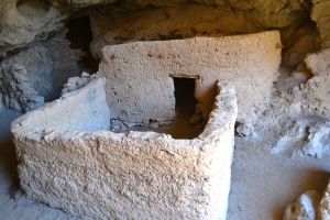
Why It’s Awesome: This is one of the most fully intact Native American cliff dwelling ruins in the State of Arizona. You can actually go up to the ruins and (very gently!) touch and photograph. Actually, don’t touch it. It’s 600 years old and you don’t want to be that guy. Check out more pictures from the trail and the ruins at the bottom of the page!


Sign Reads: This prehistoric cliff dwelling was constructed and occupied by Salado Indians approximately 600 years ago. This site is fragile and irreplaceable. Please do not climb or walk on the walls, roof, or cause any other form of disturbance or damage. This site is protected by Federal Law. Violators are subject to fines and/or imprisonment. Enjoy by do not destroy your cultural heritage.
Location: Superstition Wilderness between Phoenix and Globe.
Driving Directions: To get there from Phoenix, take U.S. Highway 60 East about three miles past Florence Junction. Turn left (northwest) on Queen Valley Road for another two or three miles. Then turn right on Forest Road 357. This is a dirt road: from this point on, four wheel drive is highly recommended. We talked to a guy who couldn’t make it on a two wheel drive, but we did see an all wheel drive, brand new Santa Fe, at the trailhead. Follow FR-357 for three miles, then turn left on FR-172 and go for 9 miles. When FR-172 changes to FR-172A go another four miles (it is steep) to the trailhead. Following the signs for the Arizona Trail and Roger’s Trough will help you stay on the right road.
GPS Coordinates of the Trail Head: 33o 25′ 16″ N 111o 10′ 25″ W
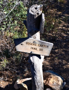
Hiking Directions: Start out on the Reavis Ranch Trail (Trail 109).You will pass the West Pinto trail, which branches off to the right (don’t take it). About 1.25 miles from the trailhead is the crossroads between Reavis Ranch Trail (which goes right) and Roger’s Canyon Trail (which goes left). Follow Roger’s Canyon Trail (Trail-110). Pay attention to the cairns as once you get into the canyon riverbed it can be easy to get off track! You will see the caves that the ruins are in directly in front of you on the trail. When you get there, it is about a 40 foot scramble up to the coolest part of the ruins. Easy to miss, so don’t!
 Duration of Hike: Approximately 8 miles. 1 hour 45 to get to the dwellings, about 4 miles. 1 hour for lunch, exploring and pictures if you are infatuated with this location like Cooper and Chelsea. 2 hours 10 minutes back to the trail head.
Difficulty of Hike: 4 out of 10. It is more along the lines of a very long nature walk. The trail is slightly overgrown, so wear pants, and there is a decent amount of river rock hopping once who get in the canyon. You cross a river bed multiple times- in the summer you may get a little wet, but we went in the winter where whatever water there was had turned to ice puddles. You are going down on a slight grade into a canyon on the way to the dwellings which means you get to go back UP! While not for the faint of heart, you will also probably not be pushing yourself to physical exertion limits.
About The People Who Built It: The Salado represent a culture which was centered in the Tonto Basin in the Superstition Mountains, about 80 miles east of Phoenix, Arizona. The Salado culture appeared about 1150 AD and dis appeared about 1450 AD. As becomes obvious after studying the available information, the Salado were a melting pot of cultures. As visitors and immigrants came through the Salado area, their practices, lifestyles and customs were adopted and adapted based on practicality, applicability and necessity to the Salado peoples. The Salado traded actively with neighbors both near and far. Seashells discovered in the villages show that the Salado traded with people from as far as Mexico and the Pacific Ocean. No one is sure about exactly what happened to the Salado people or why this particular village of Salado left this area.
See Trailhead Location:
Check out the rest of the pictures below!
- Morning View
- Trailhead Sign
- Drink Local!
- New Knife = Glory
- Always Sign The Book!
- Arizona Trail
- Ice Covered Pond
- Ice Puddles!
- River Bed
- Ruins Ahead!
- Welcome Sign
- Front Porch View
- 600 year old roof
- DON’T graffiti! 😦
- Nom nom nom!
- Fire Place
- Salado Roofing Inc.
- 40 feet up!
- Frozen Waterfall


